

Fire danger still very high
This item is available in full to subscribers.
To continue reading, you will need to either log in to your subscriber account, or purchase a new subscription.
If you are a current print subscriber, you can set up a free website account and connect your subscription to it by clicking here.
If you are a digital subscriber with an active, online-only subscription then you already have an account here. Just reset your password if you've not yet logged in to your account on this new site.
Otherwise, click here to view your options for subscribing.
Please log in to continue |
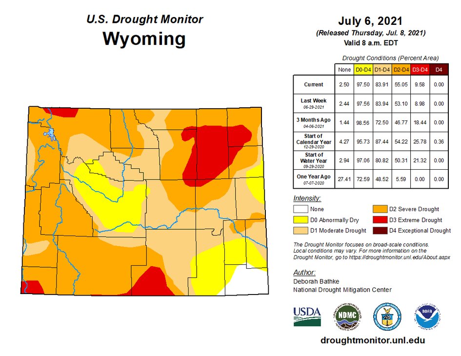
EVANSTON — As reported previously in the Uinta County Herald, ranchers and livestock producers in Uinta County are struggling to feed and water their livestock. Because of the drought conditions, hay is very limited, and, in some instances, water has to be hauled for livestock. Local ranchers have been forced to sell cattle early in order to conserve feed and water.
Good news came to local ranchers and livestock producers on June 29, when the U.S. Drought Monitor changed Uinta County from a D2 (severe drought) listing to a D3 (extreme drought) designation. Ranchers and livestock producers may now apply for the Livestock Forage Disaster Program (LFP) and for ELAP assistance for costs involved in hauling water for livestock.
Automatic federal designation for a drought applies when, during the growing season, any portion of a county meets the D2 drought intensity value for any length of time. The USDM is a map released every Thursday, showing parts of the U.S. that are in drought. The map uses six classifications: none; abnormally dry (D0) showing areas that may be going into or are coming out of drought; and four levels of drought: moderate (D1), severe (D2), extreme (D3) and exceptional (D4).
The map is produced jointly by the National Drought Mitigation Center (NDMC) at the University of Nebraska-Lincoln, the National Oceanic and Atmospheric Administration (NOAA), and the U.S. Department of Agriculture (USDA). The USDA uses the map as a trigger for programs that help agricultural producers recover from drought.
The USDM incorporates varying data: rain, snow, temperature, streamflow, reservoir levels, soil moisture and more, as well as first-hand information submitted from on-the-ground sources such as photos, descriptions and experiences. The levels of drought are connected to the frequency of occurrence across several different drought indicators. The mapmakers rely on their judgment and a nationwide network of 450-plus experts to interpret conditions for each region.
Windy Kelley, regional extension program coordinator at the University of Wyoming, is a member of Wyoming’s Condition Monitoring Team (WCMT), which works closely with Gov. Mark Gordon to provide information about drought resources to all involved in agriculture.
“The Wyoming team is made up of members from different agencies who, each week, review the monitoring report system, and draft recommendations to the national team who review it and make the final designations,” Kelley said. “The designations must be backed up with data. The drought situation is monitored every week and one author from the national team creates a new map, which is released every Thursday.”
Kelley said if anyone wants more information about drought resources, assistance programs, or stress management they can visit the governor’s new drought website: wyo.drought.gov. She said if anyone wants more information on the WCMT, they can reach her at wkelley1@uwyo.edu.
Federal and state agencies In Uinta County are diligently implementing a variety of methods and restrictions in order to mitigate the hazardous conditions of the drought.
District Forest Service Ranger Justin Robinson said the forest is in fairly decent shape right now because of the heavy storm early last winter. Range Management Specialist Aimee Cameron is working closely with the permittees on grazing management and allotments. Robinson said he thinks the forage is still about average and there is still water in the higher elevations.
“This year,” Robinson said, “we are working with permittees to set up utilization standards and prepare for next year. Our permit holders are awesome, and they work closely with us. We are hoping the normal monsoons — the humid air that comes up from the Gulf of Mexico — will come in July and bring moisture; otherwise, we will have to make some adjustments.”
To reduce the risk of human-caused wildfires during periods of high fire danger and severe fire weather conditions, the Forest Service has implemented fire restrictions within the boundaries of the Uinta-Wasatch-Cache National Forest. Those restrictions began on June 18, and will remain in effect until Sept. 30. Prohibited acts include “igniting, building, maintaining, attending or using a fire outside a fire structure that is provided by the Forest Service in a designated area and no smoking, except within an enclosed vehicle or building, a developed recreation site, or while stopped in an area at least 3 feet in diameter that is barren or cleared of any flammable material.”
Wyoming Game and Fish Department Public Information Officer Sara DiRienzo stated in the June 2021 AARP Wyoming newsletter, “Drought conditions can have severe consequences for Wyoming’s fish and wildlife because of the changes to habitat. On land, drought can lead to poor leader growth on plants like shrubs because the roots aren’t getting the necessary moisture to grow. Native forbs won’t emerge in times of drought, which means even less for wildlife to eat. That impact can last years and leave wildlife like elk, deer and pronghorn hungry.”
DiRienzo states that because of drought, invasive plant species can flourish and “choke out” native plants. The invasive plants provide little nutritional value for wildlife and they don’t support a functioning habitat. Also, aquatic species are threatened with less water and warmer water, which means less oxygen for fish.
Warmer water can also bring about a growing number of invasive fish. Warmwater predators, like bass, could travel upstream and eat the local fish community, which changes the ecosystem forever. When waterflow recedes and lake and reservoir levels drop and the water becomes warm, it also provides a great opportunity for parasites and disease to flourish.
The Wyoming Game and Fish Department is devoting considerable resources to land and water habitat improvements. In the same AARP story mentioned above, Paul Dey, aquatic habitat program manager, said their long-term statewide habitat plan will foster ecosystems on land including sagebrush country, mountains, and in streams or wetlands that are resilient to the highs and lows of water availability.
The USDA Natural Resource Conservation Service (NRCS) reported that Woodruff Narrows reservoir’s capacity has shown a severe drop — from 9,000 acre-feet to below 7,500 acre-feet — from the middle of 2018 to June 2019. James Fahey, hydrologist with Wyoming NRCS said the Woodruff Narrows is only 12% full for downstream flow.
“Looking at the final projected streamflows through the end of July for the Bear River at the Wyoming and Utah statelines — flows will be the lowest in the last 25 years at 56,000 acre-feet of water expected. Also, 80% of that total streamflow already occurred by June 15,” Fahey wrote in an email to the Herald.
In a recent story on PBS, Park Williams, a climate scientist at UCLA, said, “This drought is now 22 years old, and is just as severe as the driest 22-year periods in any of those historic mega-droughts. Since the year 2000, the western U.S. and northern Mexico has been in near-perpetual drought.”
This year is shaping up to potentially be the driest of all of the drought years in the last 100 years. In Utah, Gov. Spencer Cox declared a statewide drought emergency and asked all residents to conserve water. Lake Mead, which is created by the Hoover Dam, and is the largest reservoir in America, is getting so low it could trigger a first-ever federal shortage declaration, which could limit water for millions. The western states are projected to be hit the hardest.


