

Local officials hope for the best, prepare for the worst
This item is available in full to subscribers.
To continue reading, you will need to either log in to your subscriber account, or purchase a new subscription.
If you are a current print subscriber, you can set up a free website account and connect your subscription to it by clicking here.
If you are a digital subscriber with an active, online-only subscription then you already have an account here. Just reset your password if you've not yet logged in to your account on this new site.
Otherwise, click here to view your options for subscribing.
Please log in to continue |
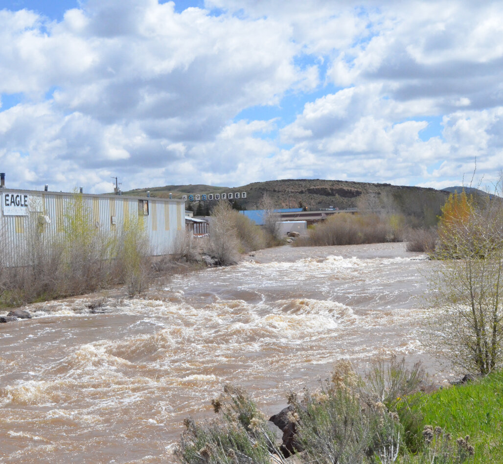
EVANSTON — Uinta County is preparing for possible floods even as officials hope for the best.
This year has brought unusually high precipitation, with massive snow storms in the Uinta Mountains and continued rain and snow throughout the spring. Entire areas across Wyoming have nearly double their average water flow for this time of year, and many also have much higher than average snowpack feeding into rivers.
According to the Wyoming Water Supply Outlook released by the National Weather Service on May 8, the entire Bear River stretching from Utah to north of Jackson has between 151-200 percent of its normal water supply.
“Overall, all the Bear River is 144 percent of normal, but a lot of those mountains are below us,” Uinta County Emergency Management Coordinator Kim West said.
He estimated that this week’s cooler weather might decrease the water levels, although it could add to the snowpack in the mountains.
Evanston’s stretch of the river is closer to the river’s beginning than areas further north, though, so it tends to get less runoff. “Less runoff” doesn’t mean “no runoff,” though.
Uinta County Sheriff Doug Matthews said the river usually overflows its banks in a few places at the Bear River State Park, but it causes little damage because it is a fairly remote area and the banks have been built up.
Evanston hydrography commissioner Travis McInnis said the river likely has a ways to go before it reaches its peak. For comparison, the peak runoff year was 2011, when the CFS measured at around 3,390. He said the area just south of Evanston also had a big peak last Saturday, May 13, at nearly 2,500 CFS (which is 126 percent of the average and was also last year’s peak on June 9.
Even so, other factors do suggest a worse-than-normal year. McInnis said Bear Lake is projected to rise 11 feet this year, the first time since 2011 (a high flood year). In Evanston, flooding is likely to be limited to flooding some people’s basements as the water table rises. The river will have much less impact if there aren’t a lot of other things thrown into the mix.
In case of emergency, the Town of Bear River has stockpiled 2,000 sandbags, and Evanston has 1,000 (filled with the help of jail inmates and local volunteer groups). Those sandbags are available by calling (307) 783-1000, although individuals must provide their own transportation except in emergencies.
McInnis said the current projection is that 192,000 acre feet will be melting and coming down at the top of the Woodruff Narrows gauge. There are some places mostly melted out, but the high reaches still have a long way to go before they’re clear.
McInnis commented wryly that there should be “decent runoff” in southwest Wyoming, which isn’t helped by higher-than-normal temperatures and precipitation. The overflow is being eased by irrigation practices, though, which can relieve the river’s burden when it is diverted.
West said that, as high as the river is running, it hasn’t reached the levels of the 2010 flooding. This year’s records are around 2,100 cubic feet per second (CFS), but in 2010, the river reached 3,890 CFS.
In addition, the river is some distance from flood stage, according to waterwatch.usgs.gov. The website lists four previous peak stages: 2010 (7.55 feet), 1984 (7.35 feet), 2011 (7.08 feet) and 1986 (6.78 feet). The National Weather Service’s flood stage for the area is 7 feet. So far this year, the highest the river has been is 5.87 feet, and the most recent record on Thursday, May 18, is 3.97 feet.
Flood risk is not just tied to snowpack, though. Average water levels, for instance, usually have a low flood risk, but other factors are involved.
“Now, at 100 percent, if it all of a sudden turns hot and we have rain on top of that, you could have some flooding, even without snow up in the mountains,” West said. “If we have a rainstorm that stalls over the top of us that dumps two or three inches of rain, we’re going to have flooding. So it’s not all tied to the snow.”
“If the snow stays up high, that would be the most ideal thing,” McInnis said, adding that there isn’t always a correlation between snowpack levels and flooding risk.
The main question is how fast the snow melts and how much continued precipitation there is.
Some of the lower areas look to be pretty much melted out, but those are just part of the story. Throughout the Bear River stretch, all the snowpacks were 156 percent of normal, although the impact will not hit everywhere evenly.
Other areas in southwest Wyoming have already been hit by flooding.
Speaking from Cokeville’s flooded town hall last Friday afternoon, Lincoln Conservation District Natural Resource Specialist Demont Grandy said the Smiths Fork usually doesn’t peak until around Memorial Day. Even so, the main branch of the river has flooded the town and has even somehow gotten into the city sewer lines.
“If it’s anything like Smiths Fork, this is one of those years we’re having extremely high water flow,” he said.
Grandy said the snowpacks in the upper Bear River are still far above the average, and on May 1, Woodruff Narrows was 89 percent full — just shy of two weeks later it was nearly full.
Afton also issued a press release on May 9, issuing a flood warning, as Spring Creek, Crow Creek, Tincup Creek and Jackknife Creek have overtopped their banks in some areas and several roads have been damaged and closed — including some roads leading to homes.
For now, officials are left to watch the weather with bated breath and hope for the best.
“It kind of depends on the weather a lot of the times on those,” McInnis said. “I know that our peak is usually on the average around that first week of June, but it kind of depends on ... how hot it is or if it’s raining or it’s snowing still.”
“I don’t have a crystal ball, so, you know, if it continues the way it is, then I think it’ll be a fairly normal spring,” West said. “And we should get through it pretty good, but if some of the things happen like rain on the snowpack and hot weather, then you know, it could be a different story.”
West cautioned people to stay away from the river, saying people who fall in have only about 5 minutes to get out before they succumb to the cold — and the water is running high, deep, muddy, cold and fast. After all, it was just recently mountain snow.


